MEEKER COUNTY, MN - DARWIN TOWNSHIP
Total Acres: 157.86±
PID #: 06-0188000 (That part of, new legal & PID# to be assigned), 06-0182000, & 06-0184010
To Be Sold in 2 Tracts!
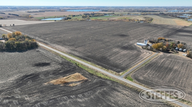
TRACT 1: Irrigated Farmland
Description: W 1/2 SW 1/4 & S 10 AC SW 1/4 NW ¼ (part), E 1/2 SE 1/4 EX N10 AC & N 10 AC NE 1/4 SE 1/4 EX N227.75'
Total Acres: 152.67±
Cropland Acres: 135.12±, approximately 97.95± irrigated acres
PID #: 06-0188000 (That part of, new legal & PID# to be assigned), 06-0182000, & 06-0184010
Soil Productivity Index: 55.5
Soils: Kanaranzi loam, 0 to 3 percent slopes (65.6%), Minneopa loam, 0 to 2 percent slopes (22.8%), Estherville sandy loam, 0 to 2 percent slopes (5.0%), MayerBiscay, depressional complex, 0 to 2 percent slopes (2.8%), Biscay clay loam, 0 to 2 percent slopes (1.8%), Cylinder loam, 0 to 2 percent slopes (1.5%), Medo, Dassel and Biscay soils, ponded, 0 to 1 percent slopes (0.5%)
Taxes (2023): $4,244.00 (For entire land. New tax amount TBD)
2002 Valley Irrigation system
TRACT 2: Country Home
Description: That part of the South 10.00 acres of the Southwest Quarter of the Northwest Quarter (SW1/4 of the NW1/4) and that part of the West Half of the Southwest Quarter (W1/2 of the SW1/4), all being in Section 20, Township 119 North, Range 30 West, Meeker County, Minnesota, described as follows: Commencing at the northeast corner of said South 10.00 acres of the SW1/4 of the NW1/4; thence on an assumed bearing of South 00 degrees 1 O minutes 31 seconds East along the east line of said SW1/4 of the NW1/4 and along the east line of said W1/2 of the SW1/4, a distance of 340.27 feet to the point of beginning of the tract of land herein described; thence North 89 degrees 26 minutes 52 seconds West, 671.08 feet; thence North 00 degrees 10 minutes 31 seconds West, 327.46 feet to the north line of said South 10.00 acres of the SW1 /4 of the NW1 /4; thence South 89 degrees 27 minutes 32 seconds West along last said line, 310.80 feet; thence South 02 degrees 03 minutes 25 seconds West, 581.08 feet; thence North 86 degrees 33 minutes 47 seconds East, 190.85 feet; thence South 02 degrees 08 minutes 43 seconds East, 57.09 feet; thence South 89 degrees 56 minutes 24 seconds East, 75.51 feet; thence North 35 degrees 23 minutes 46 seconds East, 126.86 feet; thence North 03 degrees 57 minutes 23 seconds East, 147.34 feet; thence South 89 degrees 34 minutes 08 seconds East, 652.06 feet to the east line of said W1/2 of the SW1/4; thence North 00 degrees 10 minutes 31 seconds West along last said line, 50.00 feet to the paint of beginning and there terminating.
Property Address: 24493 643rd Ave., Litchfield, MN 55355
Total Acres: 5.19±
PID #: 06-0188000 (That part of, new legal & PID# to be assigned)
Taxes (2023): $2,844.00 (For entire land. New tax amount TBD)
House Details
Unattached 3-car garage, 2-car 32’10” x 22’3”, single car 11 ’x 22’
19’4”x10’1” insulated shop within garage
Well house, 12’3” x 11’11”, well to the house has been capped and is not currently connected
Pole barn, 40’6” x 95’7”
(2) Silos
Non-compliant septic to be brought to compliance at the buyer’s expense
TERMS: Ten percent down upon signing purchase agreement, payable by cash or check. Balance due at closing after January 1, 2025. This is a 5% buyer’s premium auction.